Opened 3 years ago
Closed 17 months ago
#21364 closed defect (fixed)
[PATCH] GPX export of image new position use old coordinates
| Reported by: | StephaneP | Owned by: | StephaneP |
|---|---|---|---|
| Priority: | normal | Milestone: | 23.08 |
| Component: | Core image mapping | Version: | |
| Keywords: | template_report support-layer gpx | Cc: | Don-vip |
Description (last modified by )
What steps will reproduce the problem?
- Load some images (https://josm.openstreetmap.de/attachment/ticket/21330/bug_support_layer_A.zip)
- Export a gpx from these images, and load it in Josm
- Open the Correlate image with gpx window, and create a support layer from the previous exported Gpx
- Enable "override position", move some images, and validate the correlation.
- Export a gpx from the image positions then load it in Josm
What is the expected result?
The new exported Gpx point should be the same as the images.
What happens instead?
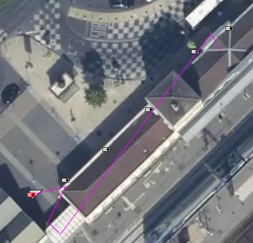
The exported Gpx file use the old images coordinates.
Please provide any additional information below. Attach a screenshot if possible.
On this screenshot, image with new coordinates, and the exported gpx.
The same process without the support layer, but with manual image (photo adjust plugin) position modification is working correctly.
URL:https://josm.openstreetmap.de/svn/trunk
Repository:UUID: 0c6e7542-c601-0410-84e7-c038aed88b3b
Last:Changed Date: 2021-09-15 00:16:42 +0200 (Wed, 15 Sep 2021)
Build-Date:2021-09-15 01:31:02
Revision:18225
Relative:URL: ^/trunk

Identification: JOSM/1.5 (18225 en) Windows 10 64-Bit
OS Build number: Windows 10 Pro 2009 (19043)
Memory Usage: 2674 MB / 7218 MB (517 MB allocated, but free)
Java version: 1.8.0_191-b12, Oracle Corporation, Java HotSpot(TM) 64-Bit Server VM
Look and Feel: com.sun.java.swing.plaf.windows.WindowsLookAndFeel
Screen: \Display0 1920×1080 (scaling 1.00×1.00)
Maximum Screen Size: 1920×1080
Best cursor sizes: 16×16→32×32, 32×32→32×32
System property file.encoding: Cp1252
System property sun.jnu.encoding: Cp1252
Locale info: en_FR
Numbers with default locale: 1234567890 -> 1234567890

Plugins:
+ DxfImport (1014)
+ Mapillary (2.0.0-alpha.36-dirty)
+ OpeningHoursEditor (35640)
+ PicLayer (1.0.1)
+ apache-commons (35524)
+ apache-http (35589)
+ areaselector (368)
+ austriaaddresshelper (1597341117)
+ cadastre-fr (35797)
+ continuosDownload (99)
+ contourmerge (v0.1.8)
+ ejml (35458)
+ geotools (35458)
+ jaxb (35543)
+ jna (35662)
+ jts (35458)
+ log4j (35458)
+ measurement (35640)
+ opendata (35803)
+ photo_geotagging (35783)
+ photoadjust (35770)
+ reverter (35732)
+ shrinkwrap (v1.0.4)
+ tageditor (35640)
+ todo (30306)
+ turnlanes-tagging (288)
+ turnrestrictions (35640)
+ undelete (35640)
+ utilsplugin2 (35792)

Tagging presets:
+ %UserProfile%\Documents\Gitlab\preset-josm-collectivites\Presets-collectivités.xml
+ https://josm.openstreetmap.de/josmfile?page=Presets/LaneAttributes&zip=1

Map paint styles:
- https://josm.openstreetmap.de/josmfile?page=Styles/Enhanced_Lane_and_Road_Attributes&zip=1
- https://josm.openstreetmap.de/josmfile?page=Styles/Lane_and_Road_Attributes&zip=1
- https://raw.githubusercontent.com/species/josm-preset-traffic_sign_direction/master/direction.mapcss
+ %UserProfile%\Documents\GitHub\MapCSS-JOSM-Bicycle\cycleway.mapcss
- https://josm.openstreetmap.de/josmfile?page=Styles/iD&zip=1
- https://github.com/bastik/mapcss-tools/raw/osm/mapnik2mapcss/osm-results/mapnik.zip
- https://josm.openstreetmap.de/josmfile?page=Styles/NewHighwayColors&zip=1

Last errors/warnings:
- 81699.827 W: java.net.UnknownHostException: wms.openstreetmap.fr
- 81699.827 W: Already here java.net.UnknownHostException: wms.openstreetmap.fr
- 81699.828 W: Already here java.net.UnknownHostException: wms.openstreetmap.fr
- 81699.828 W: java.net.UnknownHostException: wms.openstreetmap.fr
- 81699.829 W: Already here java.net.UnknownHostException: wms.openstreetmap.fr
- 81699.830 W: java.net.UnknownHostException: wms.openstreetmap.fr
- 81699.831 W: java.net.UnknownHostException: wms.openstreetmap.fr
- 81699.831 W: Already here java.net.UnknownHostException: wms.openstreetmap.fr
- 81699.832 W: Already here java.net.UnknownHostException: wms.openstreetmap.fr
- 81699.833 W: Already here java.net.UnknownHostException: wms.openstreetmap.fr
Attachments (1)
Change History (12)
by , 3 years ago
| Attachment: | old_position.jpg added |
|---|
comment:1 by , 3 years ago
| Description: | modified (diff) |
|---|
comment:2 by , 3 years ago
| Milestone: | → 21.09 |
|---|
comment:3 by , 3 years ago
| Owner: | changed from to |
|---|---|
| Status: | new → assigned |
comment:4 by , 3 years ago
| Owner: | changed from to |
|---|---|
| Status: | assigned → needinfo |
comment:6 by , 3 years ago
| Resolution: | → fixed |
|---|---|
| Status: | needinfo → closed |
comment:8 by , 3 years ago
| Resolution: | fixed |
|---|---|
| Status: | closed → reopened |
Since some releases, I noticed this bug is back. (tested with r18321)
comment:9 by , 17 months ago
I can confirm this is an issue, also in r18789.
The initial GPX export is good, but after any further changes to photo locations, the same GPX file is created every time.
comment:10 by , 17 months ago
| Milestone: | 21.10 → 23.08 |
|---|---|
| Summary: | GPX export of image new position use old coordinates → [PATCH] GPX export of image new position use old coordinates |
This is due to caching positions.
This should fix it:
-
src/org/openstreetmap/josm/gui/layer/geoimage/GeoImageLayer.java
IDEA additional info:
Subsystem: com.intellij.openapi.diff.impl.patch.CharsetEP
<+>UTF-8
diff --git a/src/org/openstreetmap/josm/gui/layer/geoimage/GeoImageLayer.java b/src/org/openstreetmap/josm/gui/layer/geoimage/GeoImageLayer.java
a b 961 961 962 962 @Override 963 963 public void imageDataUpdated(ImageData data) { 964 this.gpxFauxLayer = null; 965 this.gpxFauxData = null; 964 966 updateBufferAndRepaint(); 965 967 } 966 968


Can't reproduce with JOSM 18240 it may have been fixed in r18233. Can you please check?