| [33131] | 1 | 
|
|---|
| [30328] | 2 |
|
|---|
| 3 | ---
|
|---|
| 4 |
|
|---|
| 5 | # PointInfo plugin
|
|---|
| 6 |
|
|---|
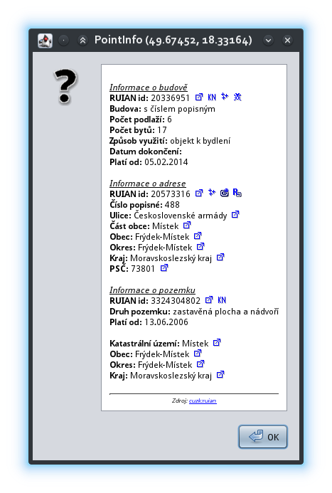
| 7 | This plugin shows all available information for clicked point from external database.
|
|---|
| [34168] | 8 | Only Czech RUIAN and Spanish Cadastre Web Services modules are available at this moment.
|
|---|
| [30328] | 9 |
|
|---|
| [30373] | 10 | Plugin could be easy extend to show another data source.
|
|---|
| 11 |
|
|---|
| [34168] | 12 | ## Author
|
|---|
| [30328] | 13 |
|
|---|
| 14 | * Marián Kyral <mkyral@email.cz>
|
|---|
| 15 |
|
|---|
| [34168] | 16 | ## Contributors
|
|---|
| [30328] | 17 |
|
|---|
| [34168] | 18 | * Javier Sánchez Portero <javiersanp@gmail.com> (Spanish Cadastre Web Services module)
|
|---|
| 19 |
|
|---|
| 20 | ## Websites
|
|---|
| 21 |
|
|---|
| [34216] | 22 | * [OSM wiki](https://wiki.openstreetmap.org/wiki/JOSM/Plugins/pointinfo)
|
|---|
| [30367] | 23 | * [JOSM svn](https://trac.openstreetmap.org/browser/subversion/applications/editors/josm/plugins/pointInfo)
|
|---|
| 24 | * [Github](https://github.com/mkyral/josm-pointInfo)
|
|---|
| 25 |
|
|---|
| [34168] | 26 | ## Licence:
|
|---|
| [30328] | 27 |
|
|---|
| 28 | * GPL v2 or later
|
|---|
| 29 |
|
|---|
| [30367] | 30 | ---
|
|---|
| [34168] | 31 | ### The RUIAN module
|
|---|
| [30367] | 32 |
|
|---|
| [34095] | 33 | * Shows data about building, addresses, streets, parcels and cadastral area from Czech RUIAN registry (https://wiki.openstreetmap.org/wiki/RUIAN)
|
|---|
| [30367] | 34 |
|
|---|
| 35 | * Additional actions are available :
|
|---|
| [33129] | 36 | * [] Open external site
|
|---|
| 37 | * [] Open external site (Katastr nemovitostí)
|
|---|
| [30368] | 38 | * [] Copy tags to clipboard
|
|---|
| [30367] | 39 | * [] Create an address point on position where was clicked
|
|---|
| 40 | * [] Create an address point on position defined in RUIAN
|
|---|
| [32132] | 41 | * [] Report an issue with building
|
|---|
| [30367] | 42 |
|
|---|
| [34168] | 43 | ### The Spanish Cadastre Web Services module
|
|---|
| 44 |
|
|---|
| 45 | * Easy access the Spanish Cadastre Web Services (only Cadastre photographs at the moment).
|
|---|
| 46 |
|
|---|
| [30367] | 47 | ---
|
|---|
| [34168] | 48 | ### The interface:
|
|---|
| [30328] | 49 |
|
|---|
| [30373] | 50 | - Input is position, output html string that is shown on message.
|
|---|
| 51 | - Optionally you can define special links (file://...) that will be sent back to the module to the performAction method
|
|---|
| 52 |
|
|---|
| [30328] | 53 | ```java
|
|---|
| 54 |
|
|---|
| 55 | /**
|
|---|
| 56 | * Get a information about given position from external database.
|
|---|
| 57 | * @param pos Position on the map
|
|---|
| 58 | */
|
|---|
| 59 | public void prepareData(LatLon pos) {
|
|---|
| 60 | }
|
|---|
| 61 |
|
|---|
| 62 | /**
|
|---|
| 63 | * Return Html text representation
|
|---|
| 64 | * @return String htmlText
|
|---|
| 65 | */
|
|---|
| 66 | public String getHtml() {
|
|---|
| 67 | }
|
|---|
| 68 |
|
|---|
| 69 | /**
|
|---|
| 70 | * Perform given action
|
|---|
| 71 | * e.g.: copy tags to clipboard
|
|---|
| 72 | * @param act Action to be performed
|
|---|
| 73 | */
|
|---|
| 74 | public void performAction(String act) {
|
|---|
| 75 | }
|
|---|
| 76 |
|
|---|
| 77 | ```
|
|---|
